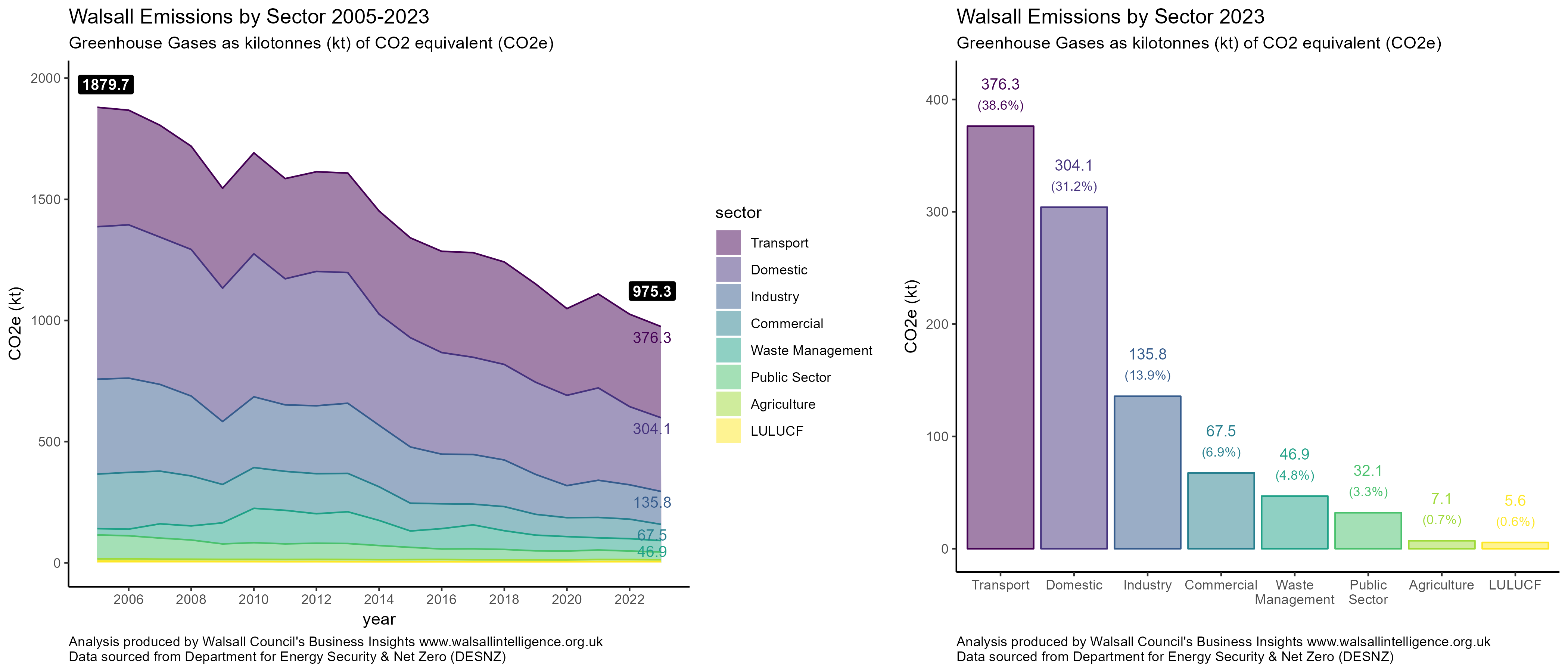
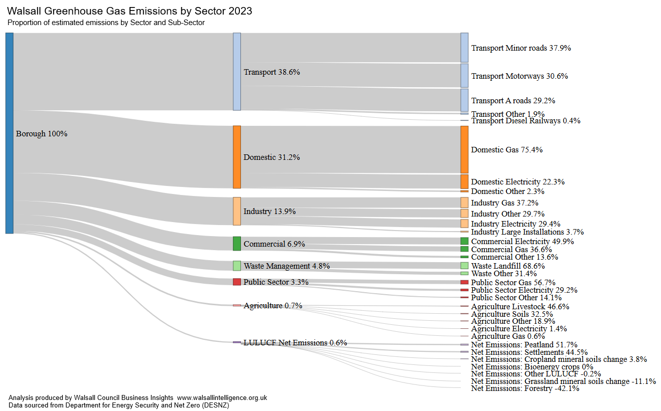
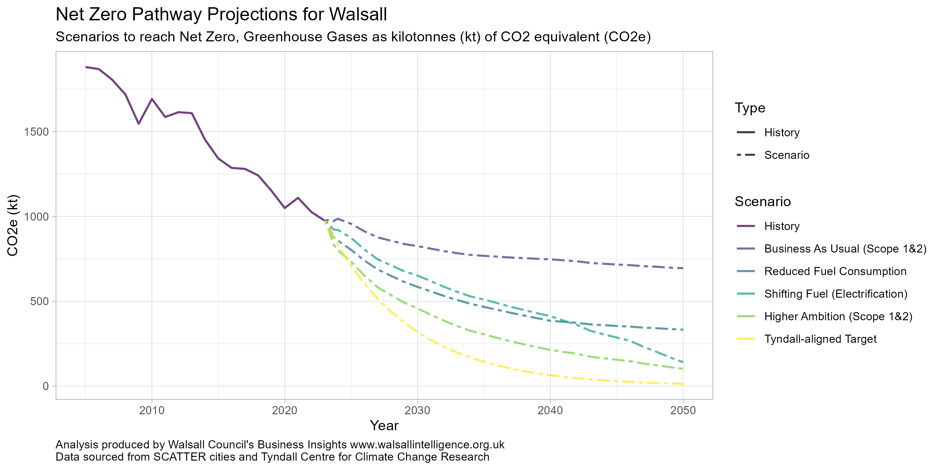
Greenhouse Gas Emissions in Walsall


In October 2022 Walsall Council committed to work with all relevant partners and stakeholders to make the whole borough net zero by 2041 in line with the regional target agreed by the West Midlands Combined Authority.

This page contains various visualisations, statistics and analyses to assess the landscape of Greenhouse Gas Emissions within the Walsall Borough.

It is a work in progress, and more will be added over the coming weeks and months as we explore the area in further detail.

Emissions by Sector


The Department for Energy Security and Net Zero (DESNZ) produces annual estimates for Greenhouse Gas Emissions by Local Authority and Sector. It suggests that Walsall produced 975.3 kt of CO2 equivalent (ktCO2e) Greenhouse Gas Emissions in 2023. Walsall’s largest sources of emissions are from Transport (38.6%), followed by Domestic (31.2%), with Industry contributing 13.9%. Relatively smaller contributors include Commercial, Waste Management and the Public Sector, emitting a combined 15% of Walsall’s emissions.

Walsall is part of the West Midlands conurbation, a largely urban area, and Agriculture and LULUCF (Land Use, Land Use Changes and Forestry) contribute the least (1.3% combined).

The long-term trend has seen substantial decreases, with a 48.1% reduction in emissions over the previous 18 years (2005-2023).

Emissions by Source


The Sankey Chart below further breaks down Greenhouse Gas Emission Estimates (Data sourced from DESNZ) into sources, highlighting the principal sources of emissions within each sector. Overall Transport was responsible for the highest emissions, at 38.6%, approximately 376.3 ktCO2e in 2023  – which is almost entirely from road vehicle use, however Domestic Gas consumption, which includes central heating, is the single largest source contributing 75.6% of all Domestic emissions (approximately 23.5% of the entire borough’s greenhouse gas volume in 2023).

Land use, Land use changes and Forestry (LULUCF) accounts for a small contribution from peatland and settlements, but is somewhat offset by Walsall’s forest and wooded land, for a net contribution of 0.6%.

Projected Greenhouse Gas Emissions


The chart below illustrates potential future greenhouse gas emissions projections, based upon a series of scenarios. The data was produced by the Tyndall Centre for Climate Change Research, sourced from SCATTER cities. The scenarios cover a range of measures: from Business as Usual (if there was no substantial change), through to a flat reduction in fuel consumption, shifting fuel consumption (towards heat pumps and electric vehicles, for instance), and wider reaching interventions such as a reduction in-line with the Tyndall sourced Paris agreement aligned rate (minimum of 13.4% reduction per year).